Burke's eight areas, from Lake Braddock to Rolling Valley: ZIP codes 22015, 22152 and 22153, the two high school zones and Zillow home values by ZIP.
Last checked Oct. 19, 2026. Sources: the Census Bureau’s boundary for the Burke census-designated place, Fairfax County’s open geospatial data (subdivision records, FCPS 2026-27 attendance areas and park boundaries), the county’s Pohick Planning District plan (archived copy, amended through March 21, 2023), the Virginia Department of Education’s School Quality Profiles, Zillow Research and OpenStreetMap.
Burke has no city limits. It is an unincorporated census-designated place in Fairfax County, about 8.6 square miles of land inside a boundary the Census Bureau draws, and the county runs its government, police, fire and parks; Fairfax County Public Schools runs the schools. That makes “which part of Burke” a question about subdivisions, school zones and ZIP codes, not city wards. This guide splits Burke into eight areas and gives each its own page.
What this means for you
- Three ZIP codes: 22015 is the Burke mailing address; 22152 and 22153 carry Springfield addresses but cover the south and east of Burke.
- Two high school zones: Lake Braddock Secondary in the north and west, West Springfield High in the south and east. School zones do not follow ZIP codes or the Census line; check any address on the FCPS boundary locator.
- Burke Centre is a separate place: it shares the 22015 ZIP code but is its own census-designated place. See Burke vs. West Springfield vs. Burke Centre vs. Kings Park West.
How Burke is laid out
Braddock Road forms Burke’s northern edge. The Norfolk Southern railroad, used by Virginia Railway Express, crosses the north of Burke, with the Rolling Road station inside Burke and the Burke Centre station just over the line. Burke Lake Road runs north and south through the middle, Old Keene Mill Road crosses east and west, and the Fairfax County Parkway curves through the south and west. Burke Lake Park, on Ox Road, lies just outside the western edge.
Fairfax County Public Schools draws the 2026-27 high school line roughly across the middle: about 62% of Burke’s land is zoned for Lake Braddock Secondary and 38% for West Springfield High. The county’s Comprehensive Plan puts Burke in the Pohick Planning District and describes most of it as Suburban Neighborhood, with retail meant to serve the neighborhoods around it.
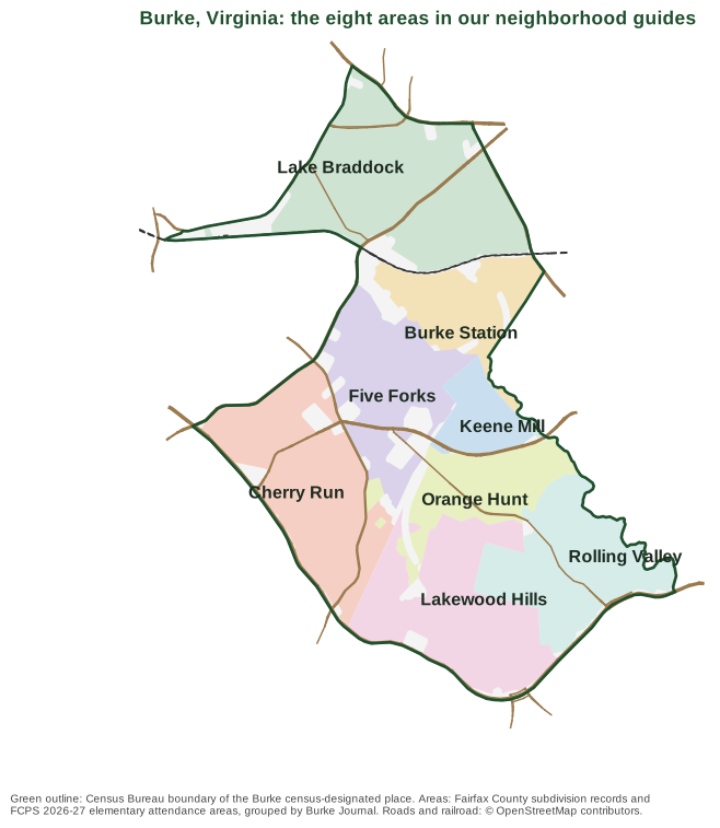
Map: Burke Journal, from the Census Bureau’s Burke boundary, Fairfax County subdivision and FCPS attendance-area data, and roads © OpenStreetMap contributors.
The eight areas at a glance
Home values are the Zillow Home Value Index for September 2026, a modeled typical value for the middle third of homes in the whole ZIP code, not a sale price. Zillow’s figure for all of Burke was $718,780.
| Area | ZIP code | Zoned high school | Typical home value in its ZIP | Guide |
|---|---|---|---|---|
| Lake Braddock | 22015 | Lake Braddock Secondary | $716,532 | Lake Braddock |
| Burke Station | 22015 | Lake Braddock Secondary | $716,532 | Burke Station |
| Five Forks | 22015 | Lake Braddock Secondary | $716,532 | Five Forks |
| Cherry Run | 22015 | Lake Braddock Secondary | $716,532 | Cherry Run |
| Keene Mill | 22152, some 22015 | Split: West Springfield 53%, Lake Braddock 47% | $676,192 (22152) | Keene Mill |
| Orange Hunt | 22152 and 22153 | West Springfield High | $676,192 (22152), $740,679 (22153) | Orange Hunt |
| Lakewood Hills | 22153 | West Springfield High | $740,679 | Lakewood Hills |
| Rolling Valley | 22152 and 22153 | West Springfield High | $676,192 (22152), $740,679 (22153) | Rolling Valley |
Lake Braddock
The north end, between Braddock Road and the railroad, around the lake of the same name and Lake Braddock Secondary. It includes the area the county plan calls Old Burke, along Burke Lake Road. Elementary schools: Kings Park and Kings Glen, or Ravensworth. Kings Park Library is here. Read the Lake Braddock guide.
Burke Station
The neighborhoods just south of the railroad along Burke Road and Rolling Road, including Burke Station Square and Homewood, about half a mile from the Rolling Road VRE station. Burke Station Park and Silas Burke Park are here. Read the Burke Station guide.
Five Forks
The middle of Burke along Old Keene Mill Road, Lee Chapel Road and Burke Lake Road, in the White Oaks Elementary zone, with the Silas Burke House and Pohick Regional Library. Read the Five Forks guide.
Cherry Run
The southwest side along Lee Chapel Road and the Fairfax County Parkway, next to Burke Lake Park, mostly in the Cherry Run Elementary zone. Read the Cherry Run guide.
Keene Mill
Shannon Station and Keene Mill Village along Old Keene Mill Road, the smallest area and the one where the high school zone splits almost in half. Read the Keene Mill guide.
Orange Hunt
Orange Hunt Estates, Greentree Village and their neighbors south of Old Keene Mill Road, mostly zoned for Orange Hunt Elementary and West Springfield High. Read the Orange Hunt guide.
Lakewood Hills
Burke’s south end around Huntsman Lake, between Huntsman Boulevard and the Fairfax County Parkway, all in ZIP 22153. Read the Lakewood Hills guide.
Rolling Valley
The southeast side along Sydenstricker Road and Hooes Road, mostly in the Hunt Valley Elementary zone, with the 1928 Sydenstricker School. Read the Rolling Valley guide.
Next door
Burke Centre, West Springfield, Kings Park West and Springfield are separate census-designated places, also governed by Fairfax County. For taxes, schools, incomes and commutes side by side, see Burke vs. West Springfield vs. Burke Centre vs. Kings Park West.
More for new residents
- Burke home prices
- Burke schools guide
- Fairfax County property taxes
- Parks and trails in Burke
- Getting around Burke
- Moving to Burke
How we built this
Burke has no official neighborhood map, so we built the areas from records we can cite:
- Fairfax County subdivision records in the county’s open data name every recorded subdivision; each area page lists the largest in it.
- FCPS 2026-27 elementary attendance areas set the edges between areas, with the railroad dividing the north. Each subdivision went to the area where most of its land lies.
- The county’s Comprehensive Plan (the Pohick Planning District chapter) supplied the Old Burke area, the park recommendations and the land-use descriptions.
- OpenStreetMap supplied neighborhood names it carries, such as Five Forks, Homewood, Edgewater and Keene Mill Heights, plus stores and roads.
Area names come from the largest subdivision, the elementary school or the OpenStreetMap place name. School and ZIP shares are shares of land, not counts of addresses, so always check a specific address. Nothing on these pages rates or ranks the areas.
Frequently asked questions
What are the neighborhoods in Burke, Virginia?
Our guide splits Burke into eight areas: Lake Braddock, Burke Station, Five Forks, Cherry Run, Keene Mill, Orange Hunt, Lakewood Hills and Rolling Valley, each built from Fairfax County subdivision records and FCPS attendance areas.
What ZIP codes are in Burke, Virginia?
22015, the Burke mailing address, plus 22152 and 22153, which carry Springfield addresses but cover the southern and eastern parts of Burke’s Census boundary.
What high schools serve Burke?
Two, on the FCPS 2026-27 map: Lake Braddock Secondary for about 62% of Burke’s land, mostly the north and west, and West Springfield High for about 38%, mostly the south and east.
Is Burke Centre part of Burke?
Not in the Census Bureau’s count. Burke Centre is a separate census-designated place to the west, though it shares the 22015 Burke ZIP code. Both are unincorporated parts of Fairfax County.
Have your say